
Northeast-Southeast/ New York City/ Bermuda. GASTALDI, G. [Venice, 1548] Tierra Nueva. 5 1/4 x 6 3/4 inches. A fine example with an uncommonly strong impression. .....
Northeast-Southeast/ New York City/ Bermuda. GASTALDI, G. [Venice, 1548] Tierra Nueva. 5 1/4 x 6 3/4 inches. A fine example with an uncommonly strong impression. .....

Northeast/ New York City. JANSSON, J. [Amsterdam, 1651] Belgii Novi, Angliae Novae, Et Partis Virginiae Novissima Delineatio. 17 ¼ x 20 ¼ inches. Superb original color; a few vertical creases else excellent with wide margins. .....

Northeast/ New Jersey. HOMANN, J. B. [Nuremberg, 1724] Nova Anglia Septentrionali Americae implantata . . . 19 ¼ x 22 ¾ inches. Fine original body color, cartouche with later color, slight fading of color along centerfold, else excellent. .....

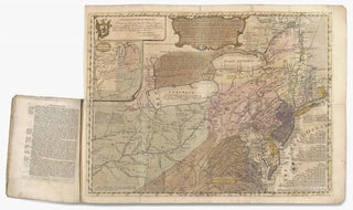
HOWELL, Reading (surveyor) / PHILLIPS, James (printer) [Philadelphia: Reading Howell: 1792 [but ca. 1794] A MAP OF THE STATE OF PENNSYLVANIA, BY READING HOWELL, MDCCXCII. Engraving on four sheets, 37 x 63 inches if joined. Lightly cleaned, minor mends, and some vertical folds from storage, yet overall a superb example. .....

New Jersey. GORDON, Thomas [Philadelphia, 1828] A Map of the State of New Jersey with part of the Adjoining States... 32 ½ x 55 ¼ inches. Engraved map, segmented and mounted to original linen backing with powder blue silk selvage as originally issued, folding into marbled paper self-wrappers. Vibrant original.....

New Jersey. SOTZMANN, D. F./ EBELING, C.D. [Hamburg: 1797] New Jersey Entworfen von D.F. Sotzmann. 25 ½ x 18 ½ inches. Copperplate engraving with period wash color; mended split left margin just entering surface, some staining, wear top & bottom margins, very good overall. .....
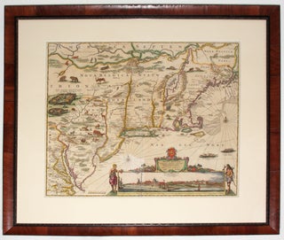
This is the most lavishly decorative of all the early editions of the best 17th century, Dutch map of the Northeast and New York. It added illustrations of animals and other detail not found on previous issues. The map was the culmination of all the surveys of the area conducted.....

SENEX, John. [London: c. 1719-21] A MAP OF LOUISIANA AND OF THE RIVER MISSISSIPI By Iohn Senex. 19 x 22 inches. Original outline color refreshed; mends in upper left and right margins, lightly age-toned, overall very good. .....
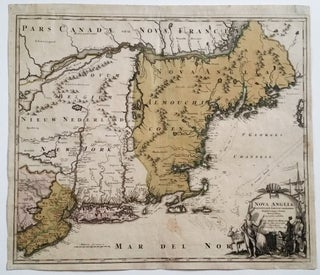
Northeast/ New Jersey. HOMANN, J. B. [Nuremberg, 1724] Nova Anglia Septentrionali Americae implantata . . . 19 ¼ x 22 ¾ inches. Fine original wash color; lightly age-toned, a few light stains, overall very good with a strong impression. .....
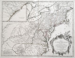
Northeast/ Mid Atlantic/ Old Northwest. ROBERT DE VAUGONDY, Didier. [Paris, 1755] Amerique Septentrionale, dressee, sur les Relations les plus modernes des Voyageurs et Navigateurs 18 ¾ x 22 ¾ inches. Original outline color; excellent condition. First state of a well-detailed map of a soon-to-be contested part.....
EVANS, Lewis/ FRANKLIN, Benjamin (printer)/ TURNER, James (engraver) [Philadelphia, 1755] A general MAP of the MIDDLE BRITISH COLONIES, in AMERICA; Viz VIRGINIA, MÀRILAND, DÈLAWARE, PENSILVANIA, NEW-JERSEY, NEW-YORK, CONNECTICUT, and RHODE ISLAND: Of AQUANISHUONÎGY, the Country of the Confederate Indians; … By Lewis Evans. 1755. The upper left cartouche reads: To the Honourable.....
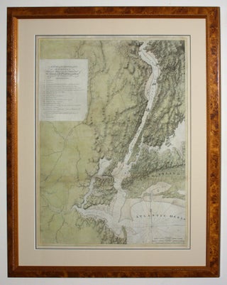
"One of the greatest of the Atlantic Neptune charts, with the best topographical information on the lower Hudson River valley, western Long Island, and Staten Island” (Nebenzahl, Bibliography). A rare and highly evocative map that provides a cartographic overview of both the ground and naval actions of the Revolutionary War.....

Battle of Brandywine/ American Revolution. FADEN, William [London, 1778] Battle of Brandywine in which The Rebels were defeated…21 x 17 inches. Troop positions in original color; light staining (from candle wax?) in lower margin, else fine condition with a strong impression. .....
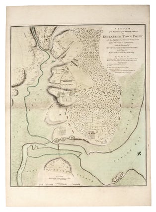
A superb example of this rare and finely engraved plan of the Battle of Elizabeth Town, New Jersey, after a manuscript by the great military cartographer John Hills. The work chronicles one of the rare engagements in the New York/ New Jersey area of the protracted middle period of the.....
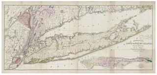
Long Island/ Manhattan/ Geology. MATHER, W. W./ SMITH, T. C. [New York?, 1842] Geological Map of Long & Staten Islands with the Environs of New York… 22 x 50 inches. Folding, lithographed map with fine, full original wash color; a few, confined toned areas, else fine condition. .....
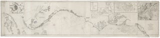
Nautical Chart: Block Island to Cuba. BLUNT, E. & G. W./ COPLEY, Charles [New York, 1853] Coast Of North America from Point Judith to Cape St. Antonio. (Island Of Cuba) Including The Bhama Banks… Every Authentic Survey, American, English & Spanish, Has Been Used In The Construction Of This Chart… 29.....
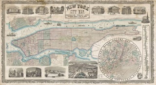
PHELPS, Humphrey [New York: 1857] Phelps' New York City Map, With Portions of Brooklyn, Jersey City, Williamsburgh, Greenpoint, Astoria, and Hoboken… 25 x 45 ¾ inches. 25 x 45 ¾ inches. Lithographed wall map with fine original color, refreshed; professionally conserved & re-backed, with some stabilized tears and a few.....
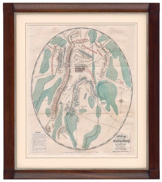
Battle of Gettysburg. DITTERLINE, T. [New York, 1864] Sketch of the Battles of Gettysburg…Compiled From The Personal Observation Of Eye-Witnesses Of The Several Battles… [Map:] Field Of Gettysburg …Prepared By T. Ditterline. Octavo in original, blue, whorled, silked paper wrappers, 24pp; now separate; chromolithographed, folding map with troop position in.....
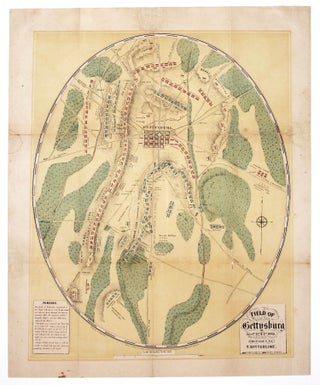
This striking, oval-shaped plan provided the American public with its first detailed and accurate visual account of one of the most significant battles in American history. It is accompanied by a pamphlet that provides an in-depth, chronological account of the complex battle. Offered here is the very rare second edition.....

RIEGEL, Jacob Jr. [Philadelphia?: 1933] University of Pennsylvania. 17 ½ x 22 ½ inches. Original two-tone print with burgundy accents. Mounted on mulberry paper, a few invisible, closed splits at lower left; overall an attractive, very good example. Original printing of a very rare pictorial map of the University of.....
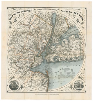
New York City/ New Jersey. G. W & C. B. COLTON & CO. [New York, 1889/ 1895] Map of the Country Thirty Three Miles Around The City of New York. 22 ¼ x 21 inches. Original wash & outline color; ex folding map with original cover, separate, map here flattened.....