
North America/ California as an Island/ Great Lakes. JANSSON, J./ HONDIUS, H. [Amsterdam, 1641] America Septentrionalis. 18 1/4 x 21 1/2 inches. Fine original color; fine condition. One of the earliest maps to focus.....
North America/ California as an Island/ Great Lakes. JANSSON, J./ HONDIUS, H. [Amsterdam, 1641] America Septentrionalis. 18 1/4 x 21 1/2 inches. Fine original color; fine condition. One of the earliest maps to focus.....

World/ California as an Island. MOLL, H. [London: 1719] A New & Correct Map Of The Whole World… 27 ¼ x 47 inches. Original outline color refreshed; mounted on rice paper, mended minor fold wear & separations, still an overall excellent, attractive example with a strong printing impression. .....

United States. FADEN, W. [London, 1796] The United States of North America with the British Territories and Those of Spain. According to the Treaty, of 1784. 20 ½ x 24 ¾ inches. Full original wash and outline color; excellent condition. .....

ANONYMOUS. [Madison, WI?: n.d. but c. 1865] Madison, The Capital of Wisconsin. Wood engraving[?] on newsprint, 28 ¼ x 41 5/8 inches at sheet edge, uncolored. Gently toned, a few tiny spots in image and minor soiling around edges. Expertly-mended cracks and tears, a few small losses to blank areas in-filled.....

Great Plains/ Denver/ Railroad & Marketing History. KNIGHT, Leonard & Co.: Chicago: c. 1895 (attributed)/ UNION PACIFIC RAILROAD. The Great Plains, on Union Pacific Railroad. Hand-colored lithograph. 17 x 35 ½ inches. Expertly cleaned, de-acidified and mounted on Japanese paper, some invisible, closed splits in bottom portion, over all a......
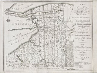
New York State/ Land Speculation. ELLICOTT, J. & B. [Philadelphia: 1801/ 1804] Map of Morris's Purchase or West Geneseo in the State of New York: Exhibiting Part of the Lakes Erie and Ontario, the Straights of Niagara, Chautauque Lake and All the Principal Waters ... Purchased by the Holland Land.....
An attractive example of a pivotal map, which inaugurated a new era in the cartography of North America, as dominance in mapmaking turned decidedly in favor of the French. In addition to being one of the earliest obtainable maps to show all five Great Lakes in a recognizable form, this.....
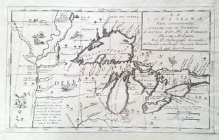
Great Lakes. CORONELLI, V. [Venice, 1695] La Louisiane. 10 ¼ x 16 ¾ inches. Lower margin expertly extended, else excellent condition. One of the first.....

SENEX, John. [London: c. 1719-21] A MAP OF LOUISIANA AND OF THE RIVER MISSISSIPI By Iohn Senex. 19 x 22 inches. Original outline color refreshed; mends in upper left and right margins, lightly age-toned, overall very good. .....
North America/ California as Island. MOLL, H. [London, 1720] To the Right Honourable John Lord Sommers . . . This Map of North America . . . 22 5/8 x 38 inches. Original outline color; few, small wormholes in upper margin, reinforcement in lower margin, else excellent condition. .....
North America/ Postal History/ Carolinas. MOLL, H. [London, 1715/ 1731] A New and Exact Map of the Dominions of the King of Great Britain on ye Continent of North America. ... By Herman Moll Geographer. ... 39 5/8 x 23 7/8 inches. Full original color; lightly toned, some folds reinforced.....
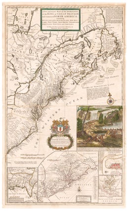
EVANS, Lewis/ FRANKLIN, Benjamin (printer)/ TURNER, James (engraver) [Philadelphia, 1755] A general MAP of the MIDDLE BRITISH COLONIES, in AMERICA; Viz VIRGINIA, MÀRILAND, DÈLAWARE, PENSILVANIA, NEW-JERSEY, NEW-YORK, CONNECTICUT, and RHODE ISLAND: Of AQUANISHUONÎGY, the Country of the Confederate Indians; … By Lewis Evans. 1755. The upper left cartouche reads: To the Honourable.....
Northeast/ Mid Atlantic/ Old Northwest. ROBERT DE VAUGONDY, Didier. [Paris, 1755] Amerique Septentrionale, dressee, sur les Relations les plus modernes des Voyageurs et Navigateurs 18 ¾ x 22 ¾ inches. Original outline color; excellent condition. First state of a well-detailed map of a soon-to-be contested part.....
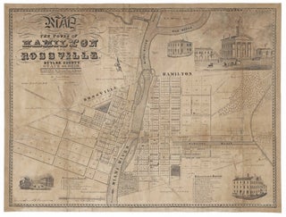
MCBRIDE, James (Mapmaker)/ KLAUPRECH & MENZEL (Lithographers)/ CAMERON, James B. (Publisher) [Cincinnati: c. 1839-1844] Map Of The Towns Of Hamilton And Rossville… 26 x 33 ¾ inches. Lithograph. Expertly conserved involving some loss of image reinstated in facsimile, particularly at top; margins almost entirely reinstated. Lingering toning and staining, again.....
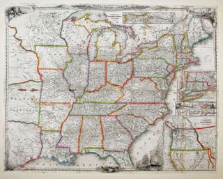
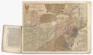
A delicately beautiful map of mid-19th century United States with extensive transportation-related content. Four of the work’s five inset maps focus on rail lines and canals in specific parts of the country. The large inset of the western United States at bottom right completes the picture of the country that.....
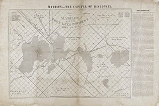
GREELEY, Horace/ FARWELL, Leonard J. [Madison?: n.d. but 1856] Map of Madison and the Four Lake Country, Dane Co. Wis. 16 ¾ x 26 ¼ inches. Ceragraphic (wax-engraved) map on thin paper. Lightly toned, some fold reinforcements, restored losses at two fold intersections and to outer margins; still good condition for.....
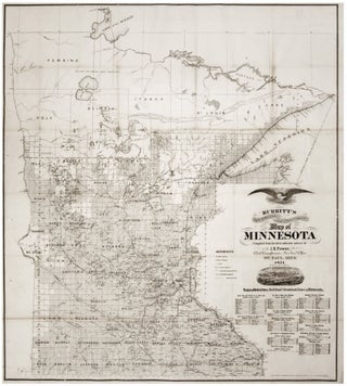
Scarce. A large, richly detailed map of the state of Minnesota, revealing the dramatic expansion of railway connections from the Great Lakes into the West. First printed in 1870, the map was quickly updated with this 1871 edition in order to keep up with the rapid changes taking place in.....
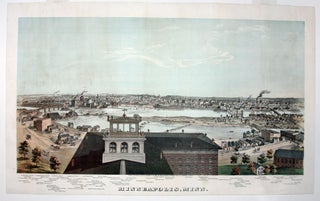
Rare and in superb condition. The second printed view of the Minneapolis, which was preceded only by Hageboeck view of 1873 and a view of both St. Anthony and Minneapolis in 1867, the year of the latter city obtained its charter. This is the larger, separately-published version of the view.....
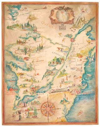
Pictorial Map/ United States/ Canada. CASS, Katherine "Kae" Dorn [Cleveland, Ohio: 1928] Untitled Manuscript of the Northeast & Midwest U. S. & Part of Canada. 26 ¾ x 21 inches. Watercolor & ink on poster board; excellent condition. Highly animated and well-executed biographical map chronicling the travels, activities, adventures and.....
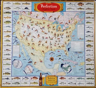
HORLACHER BREWING CO. [Allentown, Pennsylvania, 1946] Perfection Angler's Guide. 32 x 34 ½ inches. Color-printed. Excellent condition with vibrant color. A scarce, vibrant and informative promotional poster featuring two of mankind’s greatest pleasures—beer and.....