
World/ Age of Discovery. SCHEDEL, Hartmann [Nuremberg: 1493] Secunda etas mundi. 14 ½ x 20 inches. Original woodcut; usual thread hole mends, else fine condition. .....
World/ Age of Discovery. SCHEDEL, Hartmann [Nuremberg: 1493] Secunda etas mundi. 14 ½ x 20 inches. Original woodcut; usual thread hole mends, else fine condition. .....
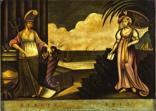
Geographic Allegorical Figures. W.B. WALKER (publisher) [London: 4 Fox & Knot Court, Cow Lane: 1805] EUROPE. ASIA. 10 ½ x 14 3/8 inches. Mezzotint, transferred to glass, finished with oil color. Slightly age-toned, small area of lower right corner chipped off, two areas of bubbling; color rich & vibrant, overall.....
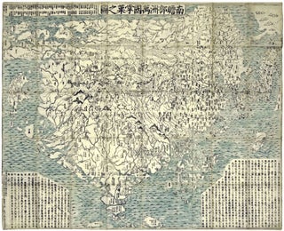
World Map/ Buddhism. Zuda RŌKASHI (Priest Hōtan) [Kyōto, c. 1710-1815] Nansen Bushu Bankoku Shōka No Zu. (“Outline Map of all the Countries of the Universe”) 45 x 57 ½ inches. Period wash color; nine woodblock sheets joined; folds reinforced, slight losses at some fold intersections, overall very good. .....

Great Plains/ Denver/ Railroad & Marketing History. KNIGHT, Leonard & Co.: Chicago: c. 1895 (attributed)/ UNION PACIFIC RAILROAD. The Great Plains, on Union Pacific Railroad. Hand-colored lithograph. 17 x 35 ½ inches. Expertly cleaned, de-acidified and mounted on Japanese paper, some invisible, closed splits in bottom portion, over all a......
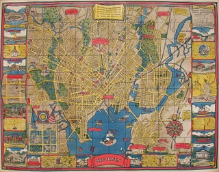
New Haven, Conn/ Yale University. MORTIMER (later MILLIGAN), Carina Eaglesfield/ EDWARD P. JUDD CO. (publisher) [New Haven: 1928] New Haven. 27 x 35 inches. Color printed; mounted on archival paper, very slight fold wear, else excellent. Delightful example of cartographic folk art that provides.....
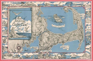
Cape Cod. MILLER, F. J. [Westwood, MA, c. 1945-1950] A Map of Interesting Cape Cod Plublished (sic) by F. J. Miller 1045 High Street Westwood, Mass. Copywright (sic) F. J. Miller Three-stone lithograph. 21 ¾ x 33 inches; with frame: 25 x 36 inches. Some fading of red border, else.....

New York City/ Transportation History. SALOMON, George [New York: 1958] OFFICIAL NEW YORK CITY SUBWAY MAP AND STATION GUIDE… Copyright, 1958 New York City Transit Authority. Designed by George Salomon. [Title repeated on verso on cover segment of map.] Color printed. 20 x 15 ¾ (printed area). Uncut & unfolded.....
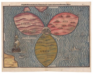
World/ Jerusalem. BUNTING, H. [Magdeburg, 1581] Die gantze Welt in ein Rieberblat…10 ¼ x 14 ¼ inches. Fine early color, refreshed; excellent condition with full margins. An exceptional, full-margined example of one of the most distinctive cartographic curiosities ever produced: a woodcut, cloverleaf-shaped map of the world with Jerusalem at.....

World/ Jerusalem. BUNTING, H. [Magdeburg, 1581] Die ganze Welt in ein Kleeblatt…10 ¼ x 14 ¼ inches. Woodcut with fine hand color; side margins extended with very slight loss, reinforced fold separations at bottom, else excellent. .....

Belgium/ Netherlands. STRADA, F. [Leiden: Jacques Marcu, 1643] Novus XVII. Inferioris German=nieae Provin=ciarum. 7 x 5/14 inches; 18 x 13 cm. Rich hand color with gold highlighting; excellent condition. .....
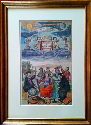
Title Page. CELLARIUS, Andreas [Amsterdam, 1660] Atlas Coelestis, seu Harmonia Macrocosmica… Image sized: 17 x 10 ¼ inches; with frame: 25 x 18 ¼ inches. Superb original color, heightened with gold; a few rubbed areas else excellent. A magnificent example, in full original color heightened with.....
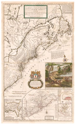
North America/ Postal History/ Carolinas. MOLL, H. [London, 1715/ 1731] A New and Exact Map of the Dominions of the King of Great Britain on ye Continent of North America. ... By Herman Moll Geographer. ... 39 5/8 x 23 7/8 inches. Full original color; lightly toned, some folds reinforced.....
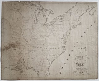
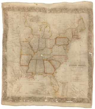
United States/Early Geographic Education/ Native American History. DAWES Jr., Samuel [Mississippi?: Dated: 1820] A Map of the United. States By Samuel Dawes Jr. 1820. [Verso:] Asia. 18 ¾ x 23 3/8 inches. Pen & ink & watercolor on woven paper. Some staining and age toning, three neatly closed splits into.....
United States/ Cartographic Curiosity. BOYNTON, George W. (engraver)/ TUTTLE, Joseph Willard (publisher) [Boston: Tremont Print Company: dated 1841] A MAP OF THE UNITED STATES, FROM THE LATEST SURVEYS. WITH THE HEIGHT OF MOUNTAINS And length of the PRINCIPAL RIVERS. PATENT. 25 3/4 x 25 inches (image not including margins). Lithographed map.....
![Item #10137 The Cerographic Missionary Atlas… [Imprint inside front cover:] Entered according...](https://rtamaps.cdn.bibliopolis.com/pictures/10137.jpg?width=320&height=427&fit=bounds&auto=webp&v=1658773966)
An unusually well-preserved, scarce, and quite early American atlas of areas where missionary activity was being, or could be conducted. Includes an excellent map exclusively of the Hawaiian Islands. A map entitled “Indian Territory” encompasses Texas and east from Lake Superior and the Mississippi River to the Rocky Mountains in.....
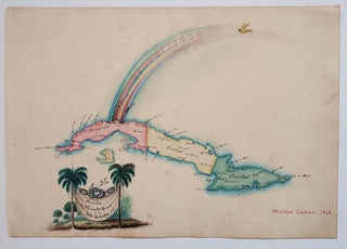
Cuba/ Opera History. CARDENA, Mariano/ BECHERINIE, F. [Havana, 1848] Arribo de Albina Steffanoni a la Isla de CUBA. 1848. 8 x 11 inches (sheet size). Manuscript in pen & ink & watercolors on heavy, watermarked wove paper, bit of soiling & toning, else excellent. [With:] A ms. sonnet titled Omaggio.....
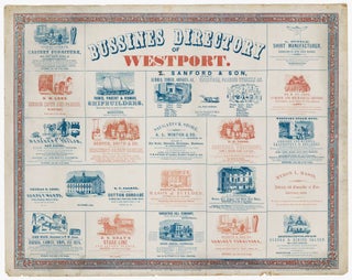
NIC. MULLER (Printer)/ NICHOLS, David (Engraver) [New York: dated October 1854] BUSSINES (sic) DIRECTORY OF WESTPORT. 20 ½ X 25 ½ inches. Two-stone lithograph (red and blue) mounted on heavy card stock. Two mended 4-inch splits at right and left, a few other mended splits entering printed surface, some edge.....

CHS. MAGNUS LITH ?/ [New York: c. 1860] Untitled View of Central Park. 21 ½ x 19 3/8 inches. Lithograph with period hand color, printed on the verso of a facsimile of the Bradford/ Lyne map of New York City; professionally mounted on mulberry paper with minor restoration to outer margins and.....
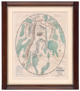
Battle of Gettysburg. DITTERLINE, T. [New York, 1864] Sketch of the Battles of Gettysburg…Compiled From The Personal Observation Of Eye-Witnesses Of The Several Battles… [Map:] Field Of Gettysburg …Prepared By T. Ditterline. Octavo in original, blue, whorled, silked paper wrappers, 24pp; now separate; chromolithographed, folding map with troop position in.....
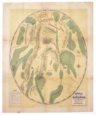
This striking, oval-shaped plan provided the American public with its first detailed and accurate visual account of one of the most significant battles in American history. It is accompanied by a pamphlet that provides an in-depth, chronological account of the complex battle. Offered here is the very rare second edition.....
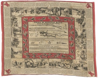
Militaria/ Arms Export History. MAKER UNKNOWN [Spain, c. 1880s] Panuelo De Instruccion Militar... 25 x 30 ¾ inches. Lithograph in red & black printed on cotton. Lightly age-toned, few small holes, overall excellent of this type. A fascinating broadside printed on cloth, illustrating the Springfield rolling block rifle, Model.....
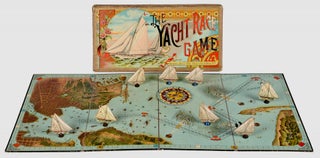
New York City & America’s Cup History. MCLOUGHLIN BROS. [1887 (copyright)/ 1888 (published)] The Yacht Race Game. Large folding game board, 31 ¼ x 16 inches. With spinner in the form of a compass and 8 (of 8) playing pieces in the form of yachts on wooden supports. All housed in.....
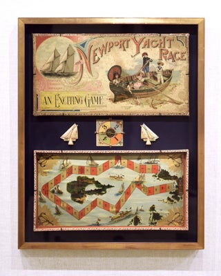
Board Game/ Newport/ Block Island. MCLOUGHLIN BROTHERS [New York: 1891] The Newport Yacht Race - An Exciting Game. Game board: 10 x19 ½ inches. Overall framed size: 29 1/4 x 23 1/4 x 1 3/4 inches. Multi-stone Lithography. Complete with cover, two sailboat game pieces, a spinning dial & instructions.....
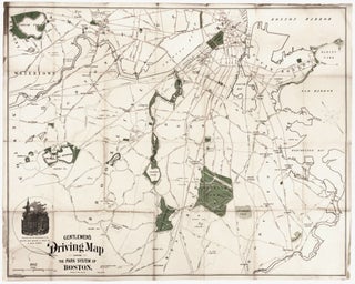
A rare map (not appearing in map market records) made of the "Gentleman" bicyclist, highlighting the not particularly ample park areas of Boston at the time. Noted with cautionary red lines are roads with street car tracks, presumably to be avoided by cyclists. Slanted green lines indicate unfinished roads. Bicycling.....
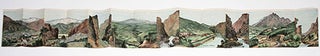
A superbly realized promotional brochure, one of the finest we've seen, issued by the Denver & Rio Grande Railroad, featuring a sequence of nine beautiful views of Colorado's mountainous natural wonders, many with trains cutting through the landscape. Fittingly the railroad's original motto was "Through the Rockies, not around them.".....