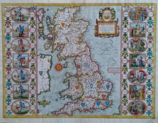
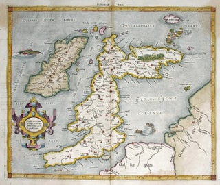
Europe
Out of stock
Septentrionalium Regionum descrip.
One of Ortelius’s most important European maps, in an attractive example. It clearly summarizes what 16th century geographers believed of northern Europe and the waters above it. In his atlas, Ortelius cited an array of cartographers whose ideas contributed to this map, including several whose maps are now unobtainable. Greenland.....
Great Britain. SPEED, John [London, 1610 [1616]] The Kingdome of Great Britaine and Ireland. 15 x 20 1/8 inches. Fine hand color; fine example with a strong impression. A beautiful example of the first state of one the most visually striking maps ever produced of the British Isles, embellished with.....
Herefordshire described with the True Plot of the city Hereford.
First edition and a fine example of this picturesque map evoking the rugged, forested terrain of the western English county with its many castles. At upper right is a plan of the town of Hereford with its great cathedral at the center, where is housed the legendary, medieval world map. .....
Italia Antica di Cl: Tolmeo.
A finely engraved general map of Italy that appeared in the first atlas of Italy published in Italy. It depicts Italy with place names that were in use during the Roman Imperial Period of the Second Century A. D. While closely based on a map by Gerard Mercator from his.....
Prosp. Der Statt Parys… 1654.
Superbly realized panorama of Paris, showing it within the context of the surrounding countryside replete with windmills. It effectively recreates what the mid-17th century traveler would have seen on approaching the city from the northeast, at a distance of a few miles. This view is to be distinguished from Merian’s.....
Nordovicum.
Scarce, large-paper, Jansson edition beautifully engraved, bird’s-eye view of the English cathedral city of Norwich that was also a center of the wool trade. With vibrant, full original color. From Jansson’s magnificent, eight-volume townbook atlas.
Novissima et Accuratissima totius Italiae Corsicae et Sardiniae . .
A beautifully colored Dutch map of Italy, Sicily, Sardinia and Corsica. The cartouche is decorated with putti and a regal figure representing the city of Rome, and by extension, Civilization. On the scales in the lower left a putto plays with surveying implements. The map features many ships, and a......
Regni Sueciae Tabula Generalis.
A most attractive map with rich Dutch coloring of the period of Scandinavia centering on Sweden and Finland but including eastern Norway. Also depicted are all of present-day Estonia and part of Latvia along with a portion of northwestern Russia. The coats-of-arms of several of these nations adorn the cartouche.....
Mediolanus Milano.
This large, oblique aerial view of Milan is certainly among the most beautiful early depictions of the city known. The city's structures are shown with considerable architectural detail, especially the larger structures such as the Duomo in center of the work. In all, 256 structures are listed and keyed to.....
Plan de Paris Commence l’Annee 1734.... Leve et Desine par Louis Bretez Grave par Claude Lucas / Et Ecrit par Aubin.
One of the most ambitious and finely engraved works of urban cartography ever produced: it depicts every structure existing in Paris at the time. This remarkable engraving enables the viewer to virtually hover a few hundred feet above the city and take in the exquisite details of its architectural glories.....
Carte des Decouvertes des Russes dans la Mer Orientale….
A scarce, attractively engraved map, from Russian sources, focusing on northeastern Russia, the Bering Strait and its islands, and Alaska. It appeared in M. Marbault’s Essai sur le commerce de Russie…, which is an account of Russian trade as well as a history of Russian explorations in the areas depicted.....
Militaria/ Arms Export History. MAKER UNKNOWN [Spain, c. 1880s] Panuelo De Instruccion Militar... 25 x 30 ¾ inches. Lithograph in red & black printed on cotton. Lightly age-toned, few small holes, overall excellent of this type. A fascinating broadside printed on cloth, illustrating the Springfield rolling block rifle, Model.....
Oxford University. LEE, Kerry/ PICTORIAL MAPS, LTD. [London?, 1948] Oxford. 18 x 22 ¾ inches. Original color print on high-grade, heavy paper. Pinholes in corners of margins, else excellent condition. A particularly attractive example of this vibrantly colored and detailed, pictorial map/ view of.....
[Archive of Ionia the Enchantress].
An archive that sheds light on the life of an extraordinary woman, known on the stage as Ionia the Enchantress, and on the tangled process of disposing of property in Russia in the fraught years of the Russian Revolution. Many of the documents relate to the sale of estates in.....