
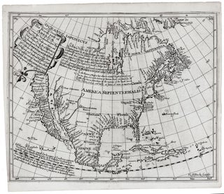
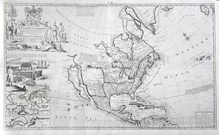
North America/ California as an Island/ Great Lakes. JANSSON, J./ HONDIUS, H. [Amsterdam, 1641] America Septentrionalis. 18 1/4 x 21 1/2 inches. Fine original color; fine condition. One of the earliest maps to focus.....
North America/ California as an Island/ Great Lakes. JANSSON, J./ HONDIUS, H. [Amsterdam, 1641] America Septentrionalis. 18 1/4 x 21 1/2 inches. Fine original color; fine condition. One of the earliest maps to focus.....

Western Hemisphere/ California as Island. SPEED, John/ HUMBLE, George [London: 1626 / c.1647-61] America with those known parts in that unknowne world both people and manner of buildings . . . Are to be sold in pops-head alley against the Exhange by G. Humble. 15 3/8 x 20 ¼ inches.....

California as Island/ Southwest/ Globe Gore. CORONELLI, V. [Venice: 1697] Della California Alcuno ha credito . . . 18½ x 12 inches. Faint staining & chipping at edges of margins, else excellent condition. A scarce globe gore showing most of an insular California by the remarkably accomplished Franciscan who is.....

World/ California as an Island. MOLL, H. [London: 1719] A New & Correct Map Of The Whole World… 27 ¼ x 47 inches. Original outline color refreshed; mounted on rice paper, mended minor fold wear & separations, still an overall excellent, attractive example with a strong printing impression. .....
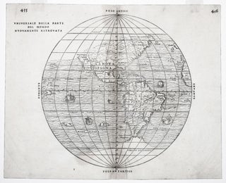
The rare first state of an important and in some ways groundbreaking map. The woodblock for this map was destroyed shortly after its publication in a fire in November of 1557, hence its rarity. The map was compiled by the great Venetian cartographer, Giacomo Gastaldi, and appeared in a three-volume.....
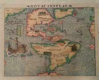
Americas. MUNSTER, Sebastian. [Basle: 1540 [c. 1544-50]] Novae Insulae. 10 ½ x 13 ½ inches. Fine early color; some age toning, a few marginal stains, else excellent. The earliest collectible map of the Western Hemisphere.....
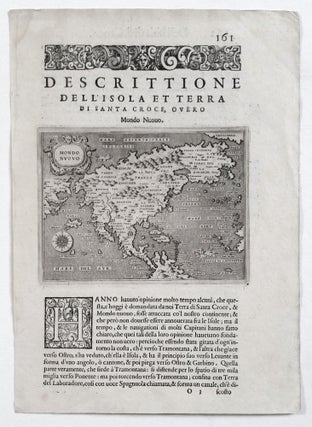
North America. PORCACCHI, Tomasso [Venice: 1572/ 1576] Mondo Nuovo. 4 ½ x 5 ¾ inches (map only). Faint tide mark upper left margin, else excellent. First state of the second earliest, obtainable map of North America, preceded only by Paolo Forlani's rare map of North America, published in Venice in.....
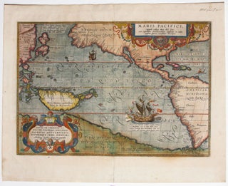
The first separate map of the Pacific in a strong example. “One of the most important maps that appeared in the Ortelius atlases ...” (Burden). With its two splendid cartouches and a well-detailed illustration of Magellan’s flagship, the Victoria, this is also one of the most beautifully engraved of Ortelius’.....
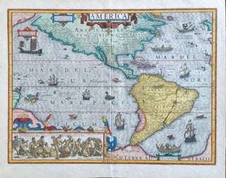
Americas/ Beer Making. HONDIUS, J. [Amsterdam, 1606] America. 14 3 4 x 19 3/4 inches. Fine hand color; fine condition with a bold strike. .....
North America/ California as an Island/ Northwest Passage. BRIGGS, H. [London, 1625] The North part of America . . . 11 3/8 x 14 inches. Excellent condition. .....
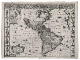
Western Hemisphere/ California as Island. SPEED, J. [London, 1626/ 1631] America with those known parts in that unknowne world both people and manner of buildings . . . 15 3/8 x 20 ¼ inches. With a strong, dark printing impression; excellent condition. .....
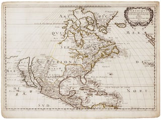
An attractive example of a pivotal map, which inaugurated a new era in the cartography of North America, as dominance in mapmaking turned decidedly in favor of the French. In addition to being one of the earliest obtainable maps to show all five Great Lakes in a recognizable form, this.....
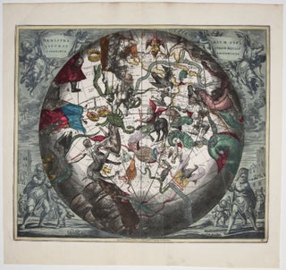
In this arresting work, constellations of the southern skies, as if viewed from deep in space, can be seen superimposed over a portion of the earth. The area depicted “beneath” the stars extends from the United States to the South Pole and includes all of South America. Because this chart.....
A splendid example, with rich, vibrant hand color, of a wall map of extraordinary intricacy and detail: "one of the most decorative maps of North America of the 18th century" (Tooley). Its elaborate illustrations provide a panorama of the Discovery Period, colorfully depicting the mores, rituals and practices of indigenous.....
North America/ California as Island. MOLL, H. [London, 1720] To the Right Honourable John Lord Sommers . . . This Map of North America . . . 22 5/8 x 38 inches. Original outline color; few, small wormholes in upper margin, reinforcement in lower margin, else excellent condition. .....
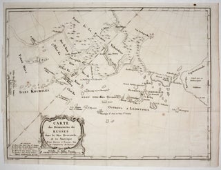
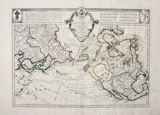
A scarce, attractively engraved map, from Russian sources, focusing on northeastern Russia, the Bering Strait and its islands, and Alaska. It appeared in M. Marbault’s Essai sur le commerce de Russie…, which is an account of Russian trade as well as a history of Russian explorations in the areas depicted.....
Alaska/Pacific/Sea of the West. SANTINI, F. / BUACHE, P./ DEL’ISLE, J. [Venice, c. 1777] Cartes des Nouvelles Decouvertes Au Nord De La Mer Du Sud, Tant a l'Ouest de la Siberie et du Kamchatka Qu' a l'Ouest de la Nouvelle France. 18 x 24 ¾ inches. Original outline color; fine.....
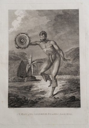
WEBBER, John (1752-1793) artist [London: G. Nicol & T. Cadell, 1784]. A Man of the Sandwich Islands, Dancing. Etched and engraved by C. Grignion after a drawing by Webber. Image size: 10 1/4 x 7 inches. Sheet size: 16 ½ x 14 inches. Lightly toned, faint tide mark upper right margin, faint.....
A beautiful example in full, vibrant, period color of a majestic, folding world map. A rare issue with very important updates. The map is an extraordinary compendium of oceanic exploration and contains voyage tracks from the 15th century to those contemporaneous with the map including those relating to polar and.....
![Item #10137 The Cerographic Missionary Atlas… [Imprint inside front cover:] Entered according...](https://rtamaps.cdn.bibliopolis.com/pictures/10137.jpg?width=320&height=427&fit=bounds&auto=webp&v=1658773966)
An unusually well-preserved, scarce, and quite early American atlas of areas where missionary activity was being, or could be conducted. Includes an excellent map exclusively of the Hawaiian Islands. A map entitled “Indian Territory” encompasses Texas and east from Lake Superior and the Mississippi River to the Rocky Mountains in.....
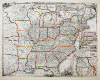
A delicately beautiful map of mid-19th century United States with extensive transportation-related content. Four of the work’s five inset maps focus on rail lines and canals in specific parts of the country. The large inset of the western United States at bottom right completes the picture of the country that.....
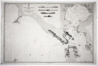
A superb, scarce, very well-preserved, mid-19th century chart of San Francisco Bay and Harbor. Although a semi-official British chart, it was based on the survey of an American Naval officer, Lt. James Alden. Under the superintendence of Capt. Washington, the Admiralty office greatly increased its output and obtained surveys sources.....
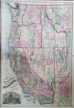
California & Western States/ Pacific Northwest/ Railroad History. WATSON, Gaylord [New York, 1876] Watson’s New County and Railroad Map of the Pacific States… 38 x 25 inches. Lithographed folding map with period hand color; extracted from original covers, retained, flattened & expertly mounted on rice paper; few splits & some.....
Attractive, richly detailed map, important for the extent of railroad information that includes even small spur lines and stations. Also significant is the table listing 545 private land grants that are keyed to the map. Using the best available sources, the map was compiled from the official records of the.....
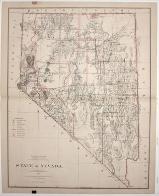
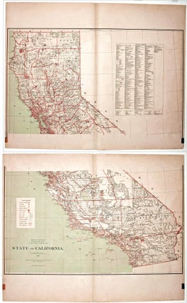
An excellent map of the state compiled from the official records of the General Land Office and other sources by C. Roeser, Principal Draughtsman of the G.L.O. Mining operations and mountain ranges are shown in considerable details. It also shows rail lines, range and township lines, cities and towns, county.....