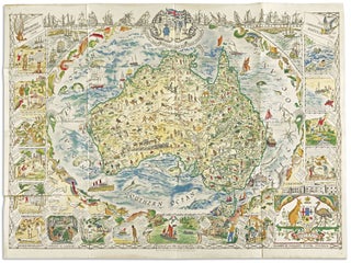
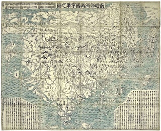
World Map/ Buddhism. Zuda RŌKASHI (Priest Hōtan) [Kyōto, c. 1710-1815] Nansen Bushu Bankoku Shōka No Zu. (“Outline Map of all the Countries of the Universe”) 45 x 57 ½ inches. Period wash color; nine woodblock sheets joined; folds reinforced, slight losses at some fold intersections, overall very good. .....
Wall Maps
Connecticut. NEVERS, R./ DAMERUM, W. [Hartford, 1851] The State of Connecticut including Parts of New York and New Jersey. 23 x 28 ¼ inches (engraved area only. Original wash hand color, refreshed; re-mounted on new linen & expertly conserved; toned, some spotting, a few splits but overall very good. In.....
Map of the Towns of Saybrook and Old Saybrook Middlesex County Connecticut.
A beautifully preserved wall map, in very attractive, period wash coloring, of the lower Connecticut towns of Old Saybrook, Essex, Deep River, Centerbrook and Ivoryton, located at or near the mouth of the Connecticut River on the eastern side. The overall map is complemented with plans of the central areas.....
Out of stock
Plan of the City of New York, in North America: Surveyed in the Years 1766 & 1767.
Rare; a superb example of the best executed and most beautiful, printed map one can acquire of early New York, and arguably, the masterpiece of 18th century, American, urban cartography. In addition to a plan of the city itself, the work provides a remarkable evocation of the pre-development landscape of.....
Asia To Major James Rennell, Esqr. F. R. S. &c. &c. This Map Is Inscribed, by His much Obliged Humble Servant January 1st 1801. A. Arrowsmith.
Very scarce, sole edition of Arrowsmith's large, folding map of Asia, the most accurate of the continent available at the time. It bears all the hallmarks that made his maps models of clarity and accessibility. "It is a significant advance on other maps of the period, incorporating the work of.....
New Hampshire. RUGGLES, Edward/ EDDY, O. T. [Walpole, NH: 1817] NEW-HAMPSHIRE, From Late SURVEY; TO THE CITIZENS of which this MAP is most respectfully Dedicated by their obedient Servant Edward Ruggles. Engraving with outline color, refreshed, on two joined sheet: 29 x 18 ½ inches. Expertly conserved & fully stabilized.....
A New Chart of the World On Mercator's Projection With The Track Of The Most Celebrated & Recent Navigators.
A beautiful example in full, vibrant, period color of a majestic, folding world map. A rare issue with very important updates. The map is an extraordinary compendium of oceanic exploration and contains voyage tracks from the 15th century to those contemporaneous with the map including those relating to polar and.....
Nantucket/ Martha’s Vineyard/ Cape Cod. ELDRIDGE, G. [Boston, 1857/ 1874] Chart of the Vineyard Sound and Nantucket Shoals… 40 ½ x 62 ½ inches. Lighthouses and other navigational aid highlighted in color; expertly conserved & re-mounted on new linen, margins extended, some relatively light staining, early notations in pencil, still.....
Washington State/ Mining History. RAND, MCNALLY & CO. [Chicago: 1890] Rand, McNally & Co.’s Sectional Map Of Washington. Scale, Eight Miles to One Inch. The Map Includes The Coeur d’Alene Mining District In Idaho… 37 1/4 x 55 3/4 inches. Lithograph with original hand color. Ex-folding map that has been.....
Maui. ALEXANDER, W. D./ DODGE, F. S. [Washington, DC: 1885/ 1903] Hawaiian Government Survey. W. D. Alexsander Surveyor-General. Maui Hawaiian Islands… 43 ¼ x 54 inches. Lithograph with bright water colors. Folding map here expertly flattened and mounted on acid-free paper and linen; a few minor mends at folds else.....
Geo. W. Eldridge’s Chart C Vineyard Sound Lt-Ship to Chatham.
An uncommonly fine example of this scarce, well-detailed yet highly legible, nautical chart of the challenging waters in the area of Martha’s Vineyard and Nantucket. It is rich with navigational detail vital to anyone plying these problematic seas, all of which is presented with Eldridge’s characteristic clarity. In addition to.....