
Northeast-Southeast/ New York City/ Bermuda. GASTALDI, G. [Venice, 1548] Tierra Nueva. 5 1/4 x 6 3/4 inches. A fine example with an uncommonly strong impression. .....
Northeast-Southeast/ New York City/ Bermuda. GASTALDI, G. [Venice, 1548] Tierra Nueva. 5 1/4 x 6 3/4 inches. A fine example with an uncommonly strong impression. .....
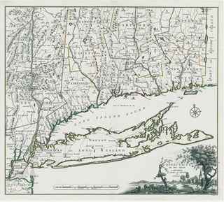
Connecticut. ROMANS, B./ COVENS & MORTIER & COVENS [Amsterdam, 1780] Connecticut and Parts adjacent… 20 ½ x 23 ¼ inches. Copperplate engraving with original outline color; all edges deckled, uncut; mint condition; in a fine archival frame. Very rare; separately published. The earliest acquirable map of Connecticut.....

Battle of Yorktown. LE ROUGE, G. L./ BERTHIER, C.-L. & L.-A. [Paris, December 1781] Plan de l’Armee de Cornwallis attaquee et faitte Prisoniere dans York Town… 12 3/8 x 15 ½ inches. Copperplate engraving. Troop positions & other details in original color; patch contemporary with publication as explained below; horizontal.....
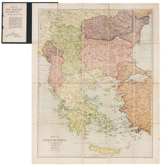
A rare, clearly printed, political map of this volatile region, described as "entirely new" in the advertisement included here. Although the map is not dated, the Royal Geographic Society reported its acquisition of an example in July of 1914 (see below). Since the Archduke Franz Ferdinand was assassinated on June.....
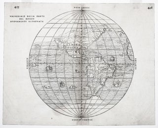
The rare first state of an important and in some ways groundbreaking map. The woodblock for this map was destroyed shortly after its publication in a fire in November of 1557, hence its rarity. The map was compiled by the great Venetian cartographer, Giacomo Gastaldi, and appeared in a three-volume.....
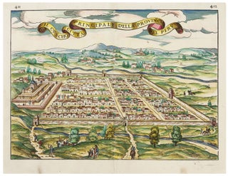
Cusco/ Peru. RAMUSIO, J. G./ GASTALDI, G. [Venice, 1556/ ?] Il Cuscho Citta Principale Della Provincia Del Peru 11 x 15 inches. Fine hand color; bit of creasing along vertical fold else fine condition .....
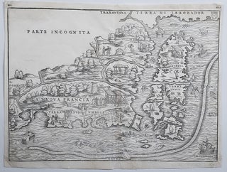
New England/ New York City. RAMUSIO, J. B./ GASTALDI, G. [Venice, 1556] La Nuova Francia. 10 1/2 x 14 1/2 inches. Woodcut map. A few minor marginal repairs, else excellent condition. .....
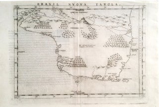
First state by Ruscelli of one of the earliest separate maps of Brazil. An erupting volcano is pictured at top center on the west-orientated map. The map appeared in an edition of Ptolemy’s Geography.

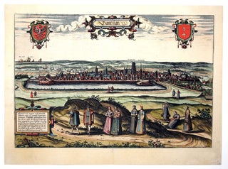
Bruges. BRAUN, G. & HOGENBERG, F. [Cologne, 1572] Brugae, Flandricarum Urbium Ornamenta. 12 ½ x 18 ¼ inches. Fine hand color with detailing in gold; excellent condition. Beautifully colored, gold-highlighted plan of Bruges, the “Venice of the north” and one of Europe's best preserved cities. The plan clearly displays the.....
This superb view of Poland’s primary seaport appeared in Braun & Hogenberg's Civitatis Orbis Terrarum, the first printed atlas of city plans and views. It accurately portrays the Town Hall Spire (marked Das Rhathaus on the view), the Church of Saint Mary (Die Phare Kirch) and more than a dozen.....
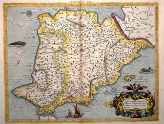
An early edition, the second, of Mercator’s definitive presentation of Ptolemy’s map of Spain and Portugal. In this map, engraved by Mercator himself, was the meeting of two of the most important figures in the history of geography. Geographic data and mapmaking instructions left by the Alexandrian, Claudius Ptolemy (fl.....
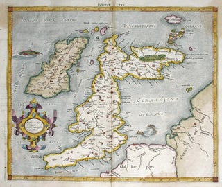
British Isles/ History of Cartography. MERCATOR, G./ PTOLEMY, C. [Cologne: 1584] Europae. I. Tab: 13 3/8 x 16 inches. Fine hand color; two light stains upper left & right (less pronounced on the actual map than in the image), else excellent condition. .....
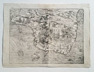
Brazil. GASTALDI, G./ RAMUSIO, J.B. [Venice, 1556/ 1606] Brasil. 10 ¾ x 14 ½ inches. Woodcut in very good condition with wide margins. One of the first separate maps of Brazil and certainly among the most richly illustrated. Indigenous peoples are depicted at various labors and activities, with an emphasis.....
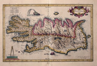
Iceland. MERCATOR, G./ HONDIUS, J. [Amsterdam, 1609] Islandia. 11 x 17 inches. Fine original color; lower centerfold reinforced, lightly toned, overall very good. .....
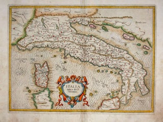
A finely engraved general map of Italy that appeared in the first atlas of Italy published in Italy. It depicts Italy with place names that were in use during the Roman Imperial Period of the Second Century A. D. While closely based on a map by Gerard Mercator from his.....
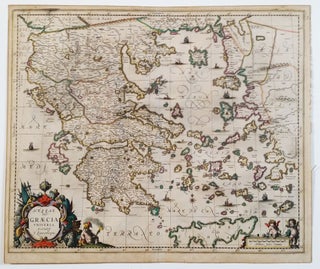
Greece/ Greek Islands. LAURENBERG, J./ JANSSON, J. [Amsterdam: 1650] Hessas. Seu Graecia Universa. Autore J. Laurenbergio. 18 ½ x 22 ¼ inches. Fine original color; lightly toned, a marginal split, else excellent. .....
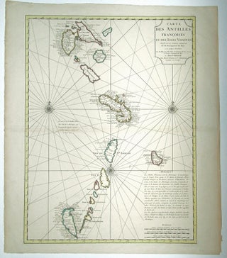
A very handsome example of De l’Isle’s map of the French Antilles, covering an area stretching from Guadeloupe in the north to Grenada in the south. Included on it are St. Vincent and the Grenadines, showing and naming both Bequia and Mustique. This is the Amsterdam edition of the map.....
Nautical Chart: Block Island to Cuba. BLUNT, E. & G. W./ COPLEY, Charles [New York, 1853] Coast Of North America from Point Judith to Cape St. Antonio. (Island Of Cuba) Including The Bhama Banks… Every Authentic Survey, American, English & Spanish, Has Been Used In The Construction Of This Chart… 29.....
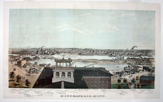
Rare and in superb condition. The second printed view of the Minneapolis, which was preceded only by Hageboeck view of 1873 and a view of both St. Anthony and Minneapolis in 1867, the year of the latter city obtained its charter. This is the larger, separately-published version of the view.....

An important, wonderfully detailed, signed and dated watercolor view of arguably the most storied western American fort, here called Camp Apache, later becoming Fort Apache. The fort was located near present-day Whiteriver in the central eastern part of Arizona. It was at the flashpoint of the decades-long Apache Wars and.....
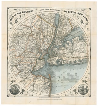
New York City/ New Jersey. G. W & C. B. COLTON & CO. [New York, 1889/ 1895] Map of the Country Thirty Three Miles Around The City of New York. 22 ¼ x 21 inches. Original wash & outline color; ex folding map with original cover, separate, map here flattened.....