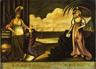
Geographic Allegorical Figures. W.B. WALKER (publisher) [London: 4 Fox & Knot Court, Cow Lane: 1805] EUROPE. ASIA. 10 ½ x 14 3/8 inches. Mezzotint, transferred to glass, finished with oil color. Slightly age-toned, small area of lower right corner chipped off, two areas of bubbling; color rich & vibrant, overall.....
Europe
Pianta Della Citta Di Roma Con La Indicazione Di Tutte Le Antichita E Nuovi Abellimenti.
Large, attractively engraved plan of Rome, flanked by 16 vignettes, each approximately 4 x 5 inches, of the city's most prominent ancient and modern structures. Included among the latter are the Pantheon of Agrippa, Trajan's Column, and the Colosseum; among the former are the basilicas of St. Peter, St. John.....
Pianta Topografica Della Citta Di Roma Dell' Anno 1829.
A finely engraved plan of Rome flanked by 15 floor plans of the city's most important structures, both ancient and more recent. It was likely intended for the more serious-minded visitor, such as northern Europeans on the Grand Tour, and for students of architecture. Pietro Ruga was active in the.....
Map Of The Balkan Peninsula….
A rare, clearly printed, political map of this volatile region, described as "entirely new" in the advertisement included here. Although the map is not dated, the Royal Geographic Society reported its acquisition of an example in July of 1914 (see below). Since the Archduke Franz Ferdinand was assassinated on June.....
Out of stock
Bruges. BRAUN, G. & HOGENBERG, F. [Cologne, 1572] Brugae, Flandricarum Urbium Ornamenta. 12 ½ x 18 ¼ inches. Fine hand color with detailing in gold; excellent condition. Beautifully colored, gold-highlighted plan of Bruges, the “Venice of the north” and one of Europe's best preserved cities. The plan clearly displays the.....
Dantzigt.
This superb view of Poland’s primary seaport appeared in Braun & Hogenberg's Civitatis Orbis Terrarum, the first printed atlas of city plans and views. It accurately portrays the Town Hall Spire (marked Das Rhathaus on the view), the Church of Saint Mary (Die Phare Kirch) and more than a dozen.....
Atlas. ORTELIUS, A./ GALLE, F. [Antwerp, 1579] Le Miroir Du Monde, Reduict Premierement En Rithme… A Anvers, De l’Imprimerie de Christofle Plantin, pour Philippe Galle. M.D.LXXIX.Oblong octavo in contemp. Vellum, ties lacking; 72 maps, 6 of which folding; slight edge wear to text leaves, partial cropping to some folding maps for.....
Napoli/ Italy. ORTELIUS, A. [Antwerp, 1579] Regni Neapolitani... 14 ¼ x 19 ¼ inches. Fine original color; oxidized area reinforced, minor loss lower centerfold & some creasing, overall fair condition. An attractive map of approximately the southern third of Italy encompassing the provinces of Apulia, Campania and Calabria and.....
Europae II Tab:.
An early edition, the second, of Mercator’s definitive presentation of Ptolemy’s map of Spain and Portugal. In this map, engraved by Mercator himself, was the meeting of two of the most important figures in the history of geography. Geographic data and mapmaking instructions left by the Alexandrian, Claudius Ptolemy (fl.....
Septentrionalium Regionum descrip.
One of Ortelius’s most important European maps, in an attractive example. It clearly summarizes what 16th century geographers believed of northern Europe and the waters above it. In his atlas, Ortelius cited an array of cartographers whose ideas contributed to this map, including several whose maps are now unobtainable. Greenland.....
Great Britain. SPEED, John [London, 1610 [1616]] The Kingdome of Great Britaine and Ireland. 15 x 20 1/8 inches. Fine hand color; fine example with a strong impression. A beautiful example of the first state of one the most visually striking maps ever produced of the British Isles, embellished with.....
Herefordshire described with the True Plot of the city Hereford.
First edition and a fine example of this picturesque map evoking the rugged, forested terrain of the western English county with its many castles. At upper right is a plan of the town of Hereford with its great cathedral at the center, where is housed the legendary, medieval world map. .....
Italia Antica di Cl: Tolmeo.
A finely engraved general map of Italy that appeared in the first atlas of Italy published in Italy. It depicts Italy with place names that were in use during the Roman Imperial Period of the Second Century A. D. While closely based on a map by Gerard Mercator from his.....
Prosp. Der Statt Parys… 1654.
Superbly realized panorama of Paris, showing it within the context of the surrounding countryside replete with windmills. It effectively recreates what the mid-17th century traveler would have seen on approaching the city from the northeast, at a distance of a few miles. This view is to be distinguished from Merian’s.....
Nordovicum.
Scarce, large-paper, Jansson edition beautifully engraved, bird’s-eye view of the English cathedral city of Norwich that was also a center of the wool trade. With vibrant, full original color. From Jansson’s magnificent, eight-volume townbook atlas.


