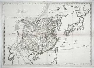
Beijing. HARRIS, John/ CAMPBELL, John [London: 1744] Plans of the Old & New City of Peking ye. Metropolis of China. 14 x 8 3/4 inches. Copperplate engraving. Excellent condition. Revealing, early plans of Beijing, formerly Peking, depicting the then contemporary city along with the ancient, original city. Legends at lower.....
China
World Map/ Buddhism. Zuda RŌKASHI (Priest Hōtan) [Kyōto, c. 1710-1815] Nansen Bushu Bankoku Shōka No Zu. (“Outline Map of all the Countries of the Universe”) 45 x 57 ½ inches. Period wash color; nine woodblock sheets joined; folds reinforced, slight losses at some fold intersections, overall very good. .....
Out of stock
Maris Pacifici, (quod vulgo Mar del Zur) . .
The first separate map of the Pacific in a strong example. “One of the most important maps that appeared in the Ortelius atlases ...” (Burden). With its two splendid cartouches and a well-detailed illustration of Magellan’s flagship, the Victoria, this is also one of the most beautifully engraved of Ortelius’.....
Quantung, Imperii Sinarum Provincia Duodecima.
An exceptionally fresh example, in brilliant original color, of the earliest separate map of the area that now includes Hong Kong. Macau, Guangzhou (Canton), and several other place names appear in the Zhu (Pearl) River delta, and Hainan Island to the southwest is quite well detailed. Finely engraved Oriental figures.....
Asia To Major James Rennell, Esqr. F. R. S. &c. &c. This Map Is Inscribed, by His much Obliged Humble Servant January 1st 1801. A. Arrowsmith.
Very scarce, sole edition of Arrowsmith's large, folding map of Asia, the most accurate of the continent available at the time. It bears all the hallmarks that made his maps models of clarity and accessibility. "It is a significant advance on other maps of the period, incorporating the work of.....
The Cerographic Missionary Atlas… [Imprint inside front cover:] Entered according to Act of Congress, in the year 1848, By Se. E. Morse & Co.,….
An unusually well-preserved, scarce, and quite early American atlas of areas where missionary activity was being, or could be conducted. Includes an excellent map exclusively of the Hawaiian Islands. A map entitled “Indian Territory” encompasses Texas and east from Lake Superior and the Mississippi River to the Rocky Mountains in.....