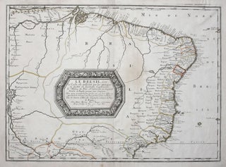
SANSON, Nicolas [Paris, 1656] Le Bresil, dont la Coste set possedeé par les portugais et diviseé en Quatorze Capitanieries. 15 ½ x 21 ¼ inches. Original outline color; excellent condition. An attractive, full-size edition of Sanson’s elegantly engraved map of Brazil. It shows the coast of South America.....
New Arrivals
United States/ New York State/ Railroads/ Advertising. HANNIFAN & CO., Publisher/ RAND MCNALLY, Printer [New York, 1886] 1885.-Railroad Map And Business Guide in Book Form.-1886.Embracing the Principal Manufacturers, Trades and Representative Business House of Utica, Rome Camden..and Schenectady. 25 ½ x 39 ½ inches. Lithographed folding map with original hand.....
Myanmar (Burma)/ Thailand/ Bangladesh. FRIES, L., PTOLEMY, C. [Lyons: 1522/ 1535] [On verso:] Tabula XI Asiae. 11 x 16 inches. Fine hand color; excellent condition. One of the earliest acquirable maps to focus on a specific region of Southeast Asia. The areas depicted on the map is primarily today’s Myanmar.....
Atlas. ORTELIUS, A./ GALLE, F. [Antwerp, 1579] Le Miroir Du Monde, Reduict Premierement En Rithme… A Anvers, De l’Imprimerie de Christofle Plantin, pour Philippe Galle. M.D.LXXIX.Oblong octavo in contemp. Vellum, ties lacking; 72 maps, 6 of which folding; slight edge wear to text leaves, partial cropping to some folding maps for.....
T-Shirt Map Series No. 1.
We are collaborating with designer extraordinaire, John Parker, of Purple Mountain Apparel, to create a series of t-shirts declaring our devotion to early maps. They are available in a full range of sizes and in several attractive colors. Free domestic shipping. To order or to see more map tee designs, click https://www.etsy.com/shop/PurpleMountainStore?ref=shop-header-name&listing_id=936549897-- which.....
Provincetown, Massachusetts. Walker Lith. & Pub Co. ]Boston: 1910] Walker’s Bird’s_Eye View of Provincetown… 10 ½ x 16 ¾ inches. Two-stone, folding lithograph on banknote paper, in original heavy paper covers, with street plan on front cover. Light glue stain at left else an excellent example. In.....
Connecticut. ROMANS, B./ COVENS & MORTIER & COVENS [Amsterdam, 1780] Connecticut and Parts adjacent… 20 ½ x 23 ¼ inches. Copperplate engraving with original outline color; all edges deckled, uncut; mint condition; in a fine archival frame. Very rare; separately published. The earliest acquirable map of Connecticut.....
World Map/ Buddhism. Zuda RŌKASHI (Priest Hōtan) [Kyōto, c. 1710-1815] Nansen Bushu Bankoku Shōka No Zu. (“Outline Map of all the Countries of the Universe”) 45 x 57 ½ inches. Period wash color; nine woodblock sheets joined; folds reinforced, slight losses at some fold intersections, overall very good. .....
NIPPON CHI.
Japanese History/ Humor. February 5, 1906 Issue of the Japanese Magazine Nippon Chi (The Land of Japan). 10 x 7 inches; wood-engraved; 67 pp. not including cover; very slight edge wear & toning, four intentional puncture holes for binding?, excellent. .....
Iraq/ World War I. PERVITITCH, Jacques [Jakub PERVITIĆ] [Constantinople: c. 1918] Irak. 18 ½ x 23 inches (47 x 58.5 cm. Color lithography, with some contemporary manuscript additions in pencil, bearing stamp of "J. Pervititch Constantinople." Mended marginal split, a few penetrating printed surface, some staining & creasing, yet still.....
Washington The Beautiful Capital Of The Nation.
A very scarce and precise "Aero View" of Washington, DC, as seen from the southeast, self described, not entirely without justification, as "the most remarkable picture map that has ever been made." With a 48-page travel guide to the city illustrating its notable attractions. Referring to a larger version of.....
1. A View of Boston from Dorchester Neck. 2. Long Island . . . 3. Boston from Willis Creek. 4. A Front View of the Lines taken from the advanced Post near Browns House. 5. A View of the Harbour of Boston taken from Fort Hill. 6. A View of the Country towards Dorchester, taken from the advanced works on Boston Neck.
The complete set of six views (on two sheets), all relating to Boston; very rarely seen complete. These fine engravings of various vistas of Boston are important records of the area prior to as well as just after the beginning of the Revolution. Three of views show Boston itself, from.....
Perrine's New Topographical War Map of the Southern States Taken from the latest government surveys and official reports. [With booklet:] A Concise History Of The War….
Large, detailed, up-to-date map of the entire theatre of the American Civil War, accompanied by a booklet that provides a day to day history of the war from its beginning to November 30th, 1863. Red circles on the map indicate the sites of engagements. Railroad lines are shown throughout, and.....