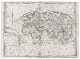
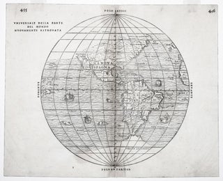
Myanmar (Burma)/ Thailand/ Bangladesh. FRIES, L., PTOLEMY, C. [Lyons: 1522/ 1535] [On verso:] Tabula XI Asiae. 11 x 16 inches. Fine hand color; excellent condition. One of the earliest acquirable maps to focus on a specific region of Southeast Asia. The areas depicted on the map is primarily today’s Myanmar.....
Asia
Aden, Arabiae Foelicis Emporium….
One of relatively few engravings by Braun & Hogenberg of non-European locales. The earliest acquirable European view of Aden in Yemen, the Arabian port commanding the passage between the Red Sea and the Indian Ocean. Also pictured are Mombasa in Kenya, Kilwa in Tanzania, and Sofala in Mozambique, all on.....
Beijing. HARRIS, John/ CAMPBELL, John [London: 1744] Plans of the Old & New City of Peking ye. Metropolis of China. 14 x 8 3/4 inches. Copperplate engraving. Excellent condition. Revealing, early plans of Beijing, formerly Peking, depicting the then contemporary city along with the ancient, original city. Legends at lower.....
Asia To Major James Rennell, Esqr. F. R. S. &c. &c. This Map Is Inscribed, by His much Obliged Humble Servant January 1st 1801. A. Arrowsmith.
Very scarce, sole edition of Arrowsmith's large, folding map of Asia, the most accurate of the continent available at the time. It bears all the hallmarks that made his maps models of clarity and accessibility. "It is a significant advance on other maps of the period, incorporating the work of.....
Geographic Allegorical Figures. W.B. WALKER (publisher) [London: 4 Fox & Knot Court, Cow Lane: 1805] EUROPE. ASIA. 10 ½ x 14 3/8 inches. Mezzotint, transferred to glass, finished with oil color. Sightly age-toned, small area of lower right corner chipped off, two areas of bubbling; color rich & vibrant, overall.....
World Map/ Buddhism. Zuda RŌKASHI (Priest Hōtan) [Kyōto, c. 1710-1815] Nansen Bushu Bankoku Shōka No Zu. (“Outline Map of all the Countries of the Universe”) 45 x 57 ½ inches. Period wash color; nine woodblock sheets joined; folds reinforced, slight losses at some fold intersections, overall very good. .....
Singapore/ Parts of Malaysia, Borneo & Java. JAMES IMRAY & SON [London: 1880] East India Archipelago [Western Route to China. Chart No.2]… 1880. 49 x 40 inches, 124.5 x 101.7 cm. Two joined, lithographed sheets mounted on new, heavy blue paper with original trade label affixed. Courses with positions and.....
Map Of The Balkan Peninsula….
A rare, clearly printed, political map of this volatile region, described as "entirely new" in the advertisement included here. Although the map is not dated, the Royal Geographic Society reported its acquisition of an example in July of 1914 (see below). Since the Archduke Franz Ferdinand was assassinated on June.....
Iraq/ World War I. PERVITITCH, Jacques [Jakub PERVITIĆ] [Constantinople: c. 1918] Irak. 18 ½ x 23 inches (47 x 58.5 cm. Color lithography, with some contemporary manuscript additions in pencil, bearing stamp of "J. Pervititch Constantinople." Mended marginal split, a few penetrating printed surface, some staining & creasing, yet still.....
NIPPON CHI.
Japanese History/ Humor. February 5, 1906 Issue of the Japanese Magazine Nippon Chi (The Land of Japan). 10 x 7 inches; wood-engraved; 67 pp. not including cover; very slight edge wear & toning, four intentional puncture holes for binding?, excellent. .....
Out of stock
Jerusalem. MUNSTER, S./ CLAUSER, J. [Basel, 1550] Ierusalem civitas sancta, olim metropolis regni Iudaici, hodie vero colonia Turcae. 11 x 14 ¾ inches (image and text). Woodcut with fine hand color; fine condition. Original woodcut view of Jerusalem of the mid-1550s. Unlike most early depictions of the city, this.....
La Figure du Monde Universel.
An excellent example of this early, woodcut world map, rich in the imagery of the Discovery Period with its many sea monsters and surrounding wind heads. The map provides an overview of the known world of the mid-16th century, just after the first great wave of New World discoveries. The.....
Universale Della Parte Del Mondo . .
The rare first state of an important and in some ways groundbreaking map. The woodblock for this map was destroyed shortly after its publication in a fire in November of 1557, hence its rarity. The map was compiled by the great Venetian cartographer, Giacomo Gastaldi, and appeared in a three-volume.....
Maris Pacifici, (quod vulgo Mar del Zur) . .
The first separate map of the Pacific in a strong example. “One of the most important maps that appeared in the Ortelius atlases ...” (Burden). With its two splendid cartouches and a well-detailed illustration of Magellan’s flagship, the Victoria, this is also one of the most beautifully engraved of Ortelius’.....
Quantung, Imperii Sinarum Provincia Duodecima.
An exceptionally fresh example, in brilliant original color, of the earliest separate map of the area that now includes Hong Kong. Macau, Guangzhou (Canton), and several other place names appear in the Zhu (Pearl) River delta, and Hainan Island to the southwest is quite well detailed. Finely engraved Oriental figures.....
Holy Land/ Judaica. VISSCHER, Nicolaus [Amsterdam: c. 1657] Peregrinatie ofte Veertich-Iarige Reyse Der Kinderen Israels,,… 12 ½ x 18 ¾ inches. Copperplate engraving with fine, early color; bottom of centerfold reinforced, a few mended edge splits, none affecting engraved area, overall excellent. A finely engraved and colored map, from a......
The Cerographic Missionary Atlas… [Imprint inside front cover:] Entered according to Act of Congress, in the year 1848, By Se. E. Morse & Co.,….
An unusually well-preserved, scarce, and quite early American atlas of areas where missionary activity was being, or could be conducted. Includes an excellent map exclusively of the Hawaiian Islands. A map entitled “Indian Territory” encompasses Texas and east from Lake Superior and the Mississippi River to the Rocky Mountains in.....